Cyclone Ingrid 20050312 Precipitation Map Northern Australia - stock illustration
Precipitation Weather Map of Tropical Cyclone Ingrid over the Arafura Sea on March 12, 2005. All source data is in the public domain. Made with data courtesy from Goddard Earth Sciences Data and Information Services Center (GES DISC), NOAA. NCEP/CPC L3 Half Hourly 4km Global Merged IR V1. Countries and Boundaries: Made with Natural Earth.

Get this image in a variety of framing options at Photos.com.
PURCHASE A LICENSE
All Royalty-Free licenses include global use rights, comprehensive protection, simple pricing with volume discounts available
€300.00
EUR
Getty ImagesCyclone Ingrid 20050312 Precipitation Map Northern Australia High-Res Vector Graphic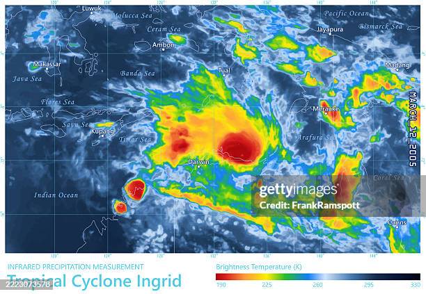 Download premium, authentic Cyclone Ingrid 20050312 Precipitation Map Northern Australia stock illustrations from 51łÔąĎÍř Explore similar high-resolution stock illustrations in our expansive visual catalogue.Product #:2223073578
Download premium, authentic Cyclone Ingrid 20050312 Precipitation Map Northern Australia stock illustrations from 51łÔąĎÍř Explore similar high-resolution stock illustrations in our expansive visual catalogue.Product #:2223073578€300€40
Getty Images
In stockDETAILS
Credit:
51łÔąĎÍř #:
2223073578
License type:
Collection:
DigitalVision Vectors
Max file size:
4924 x 3403 px (16.41 x 11.34 in) - 300 dpi - 12 MB
Upload date:
Location:
Australia
Release info:
No release required
Categories:
- Meteorology Illustrations
- Weather Illustrations
- Weather Map Illustrations
- Cyclone Illustrations
- Australia Illustrations
- Map Illustrations
- Computer Graphic Illustrations
- Data Illustrations
- Extreme Weather Illustrations
- Indonesia Illustrations
- Radar Illustrations
- Rain Illustrations
- Sea Illustrations
- Temperature Illustrations
- 2005 Illustrations
- Accidents and Disasters Illustrations
- Arafura Sea Illustrations
- Calendar Date Illustrations
- Cartography Illustrations
- City Illustrations
- Color Image Illustrations
- Danger Illustrations
- Darwin - Australia Illustrations
- Digital Composite Illustrations
- Digitally Generated Image Illustrations
- Environment Illustrations
- Flood Illustrations
- Geographical Border Illustrations
- Horizontal Illustrations
- Illustration Illustrations
- Indian Ocean Illustrations
- Infographic Illustrations
- Infrared Illustrations
- Instrument of Measurement Illustrations
- Low Illustrations
- March - Month Illustrations
- Natural Disaster Illustrations
- No People Illustrations
- Northern Territory - Australia Illustrations
- Pacific Ocean Illustrations
- Physical Geography Illustrations
- Science Illustrations
- Storm Illustrations
- Text Illustrations
- Threats Illustrations
- Time Illustrations
- Vector Illustrations
- Wind Illustrations